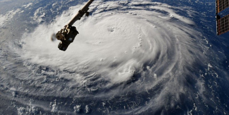
La imagen fue tomada en la mañana del 6 de septiembre.
Los vientos llegaron a 121 kilómetros por hora, justo por encima de la velocidad para ser considerada huracán.
Aún es muy pronto para predecir la ruta exacta pero gran parte del área costera desde el norte de Florida hasta Carolina del Norte deberían prepararse, indicaron del Centro Nacional de huracanes en Miami.
“Todo indica que florence será huracán extremadamente peligroso categoría 4 mientras va sobre el Atlántico occidental rumbo al sureste de Estados Unidos”, afirmaron.
#HurricaneFlorence strengthens in the early morning hours over the Atlantic. pic.twitter.com/IEdn1VQk9k
— Ricky Arnold (@astro_ricky) 6 de septiembre de 2018
Cameras outside the station captured views of Hurricane Florence in the Atlantic at 8:10 a.m. EDT Sept. 10. With winds of 115 miles an hour it could make landfall along the eastern seaboard of the U.S. late Thursday or early Friday. pic.twitter.com/DhEHhSeeDx
— Intl. Space Station (@Space_Station) 10 de septiembre de 2018
Hurricane #Florence this morning as seen from @Space_Station. A few moments later, #Isaac & the outer bands of #Helene were also visible. pic.twitter.com/WJQfS4au4m
— Ricky Arnold (@astro_ricky) 10 de septiembre de 2018
También te puede interesar: